Data and models used
The aquifer model is based on the digital geological model DGM-Deep v5.0. This consists of 13 national maps (on+offshore) of base depth and thickness of different geological units (Groups). The depths and thicknesses are based on seismic mapping, and calibrated to over 3,500 borings. A detailed description of the modeling of DGM-deep v5.0 can be found at NLOG.nl. Compared to DGM-Deep v4.0, used for ThermoGIS v2.1, in DGM-Deep v5.0 the base of the Upper Germanic Trias Group has been added. For Formation of Zeeland Formation aquifer ('Dinantian' or 'Kolenkalk') of Early Carboniferous age, results from the SCAN Dinantian project were used.
A Group always consists of several layers, some of which are potentially suitable for geothermal energy (aquifers), and some of which are not (aquitards). For ThermoGIS, aquifers have therefore been mapped within the DGM-Deep Groups. Compared to ThermoGIS v2.1, the depth and thickness maps of the aquifers from the Cretaceous, Jurassic, Triassic and Rotliegend have been recreated. The Paleogene layers were not re-mapped, with the exception of the Brussels Sand Member. Of the latter aquifer, both depth and thickness have been seismically mapped. The aquifers of Carboniferous age were also not re-mapped.
On the seismic on which DGM-Deep is based, the aquifers cannot always be identified. Therefore, depth and thickness information from the nearly 3,900 onshore boreholes with a total depth of more than 500 metres was used for their mapping. The sets of boreholes used for the calibration of DGM-Deep and aquifer mapping, respectively, differ from each other. Also, layer depths in boreholes may differ from seismic-based depths because the latter are measured in time and converted to depth using a time-depth model. As a result, DGM-Deep layer depths may conflict with aquifer layers.
Data preparation
Not all nearly 3900 deep boreholes can be used for aquifer mapping. Boreholes can be excluded on the following grounds::
- Geologically: borehole has unreliable interpretation of depths, borehole is intersected by one or more faults.
- Technically: not or poorly logged borehole, unreliable deviation survey, etc.
The resulting set of boreholes was categorized into four types for each aquifer::
- The aquifer is drilled in its entirety. The observed thickness is used for modelling.
- The depth of the borehole (total depth TD) is within the aquifer. The thickness of the aquifer should be at least equal to that from this drilling.
- The aquifer was not encountered in the borehole, but an older layer was encountered. The thickness for modelling purposes is set to 0.
- The aquifer is not described as such in the borehole, but the associated (main) Group is (e.g.: the Lower North Sea Group is described in the borehole but not the individual Formation or Member). Based on regional knowledge, it can be assumed that the aquifer should logically be present - e.g. due to incomplete stratigraphic coding of the borehole. These aquifer depths are ignored..
Method
The depths and thicknesses of the aquifers were mapped by modelling the depths and thicknesses measured in the boreholes relative to the base of the Group to which they belong, and stacking them between base and top. Exceptions are:
- the Brussels Sand Member: entirely based on seismic interpretation, supported by borehole data in areas with no or little seismic coverage;
- the Slochteren Formation (Rotliegend): top based on the base Zechstein mapped on seismic, taking into account the Ten Boer Member which is situated between the Zechstein and the Slochteren Formation. Thickness based on borehole data.
- Zeeland Formation (Dinantian): top based on seismic data, thickness based seismic data where base Dinantian is visible
'Consistent' versus 'inconsistent'
Areal extent polygons of the individual aquifers were determined based on the DGM-Deep v5.0 areal extent polygons of the corresponding Group and stratigraphically labelled boreholes. The difference between the Group base and that of the aquifer is calculated for each borehole. This difference is interpolated within the determined areal extent using the Kriging algorithm and added to the Group base. The resulting map is the base of the aquifer. The aquifer thickness determined in the boreholes is then interpolated. This yields a thickness map of the aquifer. The calculated thickness is added to the base, resulting in a map of the top of the aquifer.
When calculating the aquifer thickness, the Kriging standard deviation is also calculated. This reflects the uncertainty of the modelling, but does not say anything about the uncertainty of the depths and thicknesses determined in the boreholes.
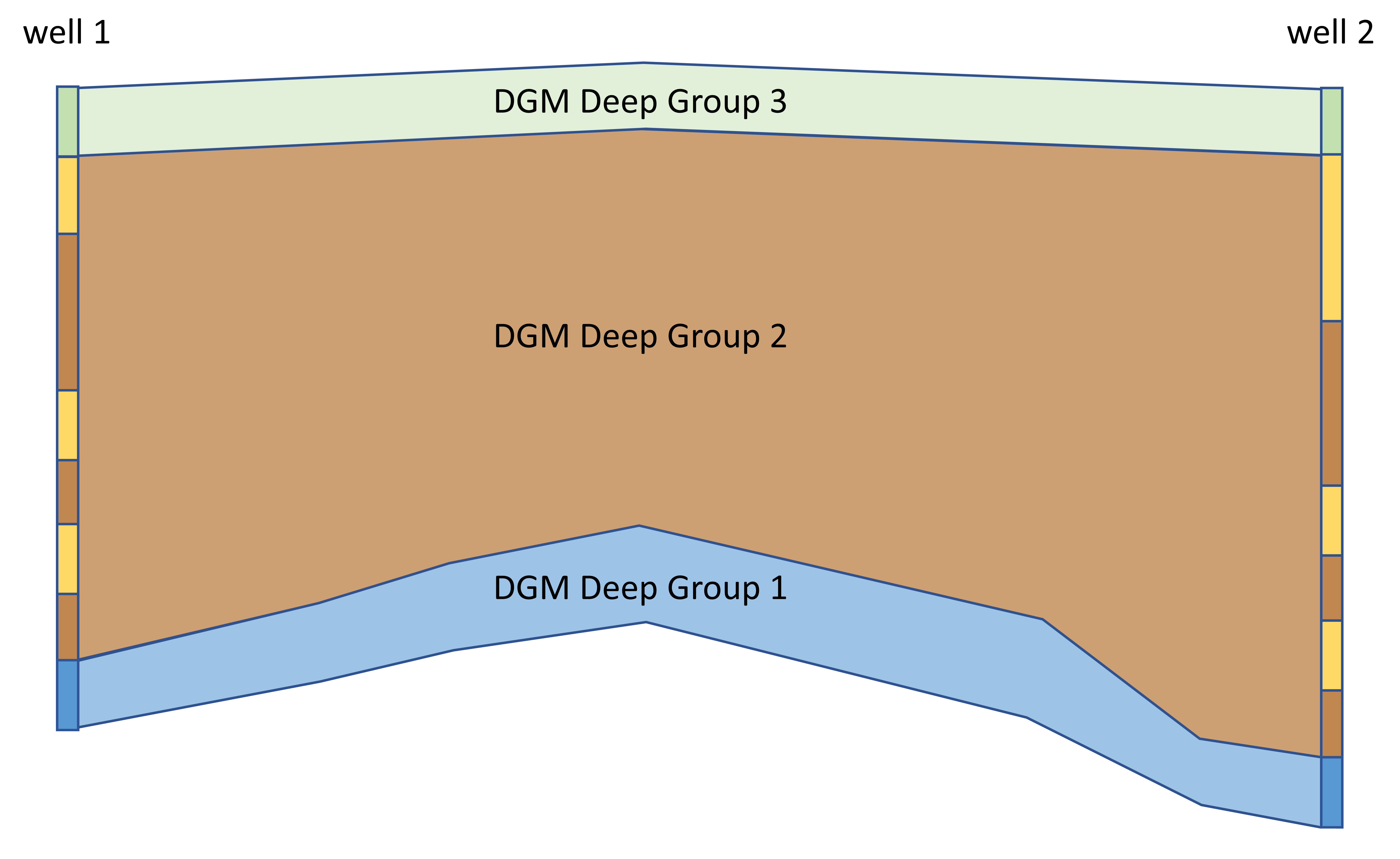
The sum of the modelled thicknesses of all individual aquifers (and, implicitly, intermediate aquitards) can potentially be larger than the difference between the bottom and top of the (main) Group interpreted in seismic data. This effect may be caused by uncertainty in interpolation, seismic time-depth conversion, misinterpretations of seismic data and/or boreholes, or the use of different sets of boreholes between DGM-Deep and for the aquifer depth / thickness modelling (cf. Table 1). This implies that model layers may cross each other.
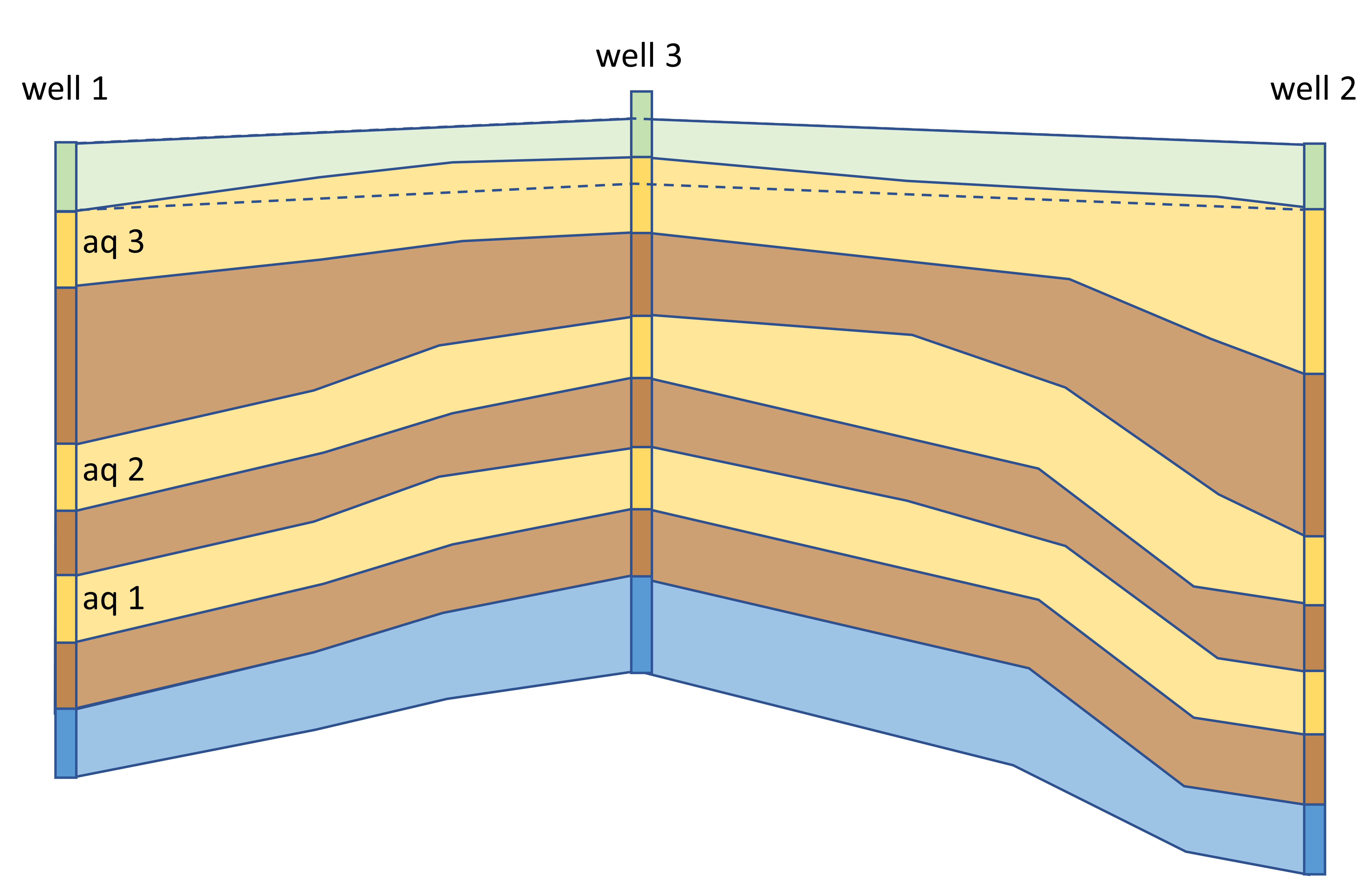
The figure below illustrates this effect. The upper part shows a hypothetical cross-section through the DGM-Deep model in which three units are mapped using seismic data, and whose depths are calibrated using two boreholes well 1 and well 2. The bottom section shows that three aquifers have been modelled within DGM-Deep Group 2, based on the two DGM-Deep borings plus a third borehole. This latter borehole has a top Group 2/base Group 3 that conflicts with DGM-Deep. In the 'consistent' case, the DGM-Deep surface is leading, and aquifer 3 will be cut off above the dotted line dotted in (b) - the base of DGM-Deep Group 3. Aquifers made 'consistent' in this way can then be assigned a thickness of 0 within the assumed areal extent. The final areal extent is then determined by thicknesses exceeding 0 metres. This 'consistent' method can lead to underestimation of the geothermal potential and is therefore no longer used in the current version of ThermoGIS. Instead, in the 'inconsistent' case, the information from the additional borehole well 3 is leading, and the top of the modelled aquifer 3 will be above the Group 3 base.